Enregistrez gratuitement cette image
en 800 pixels pour usage maquette
(click droit, Enregistrer l'image sous...)
|
|
Réf : T01698
Thème :
Terre vue de l'espace - Iles - Récifs (286 images)
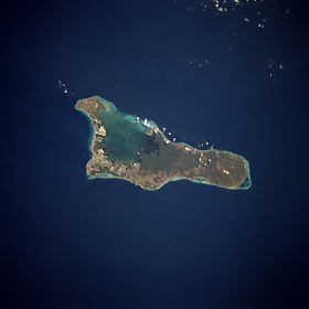
Titre : Grand Cayman, Cayman Islands April 1994
Description : (La description de cette image n'existe qu'en anglais)
The island of Grand Cayman, a British dependency that covers 76 square miles (197 square kilometers) in the northwest Caribbean Sea, is visible in this near-vertical photograph. Geologically similar to The Bahamas, Grand Cayman is a low-lying, limestone island located on top of a submarine ridge. The city of George Town, the capital and chief port of the Cayman Islands, can be seen at the southwest end of the island. Grand Cayman was discovered in 1503 by Christopher Columbus but was never occupied by Spain. The island was settled in 1734 by English colonists from the island of Jamaica, approximately 200 miles (320 kilometers) to the southeast. The word Cayman is derived from the Carib Indian word for alligator, apparently because early British visitors saw large lizards (probably iguanas), which they mistook for alligators. Grand Cayman’s 7-mile beach can be seen on the western side of the island. With exotic coral reefs off its shores, Grand Cayman is a mecca for divers. Today, tourism is the major industry of the island.
|
|

